 In the long history of transit planning in Los Angeles, early documents focused on relieving congestion with new street plans. Shortly after phenomenal growth in both area and population before World War II, various studies and reports outlined ambitious plans for moving people greater distances in a shorter amount of time.
In 1946, the Interregional, Regional, Metropolitan Parkways report proposed an extensive system of highways and parkways criss-crossing the entire county. It explained that
While parkway construction is often more expensive per mile than a substantial widening of a business thoroughfare, it is much cheaper in results. A single lane of parkway roadway will carry 1,500 cars per hour at average speeds of 35 to 40 miles per hour, compared with 500 to 700 cars per hour at average speeds of 15 to 20 miles per hour for the surface street traffic lane.
The report went on to propose that
The parkways of the Los Angeles Metropolitan Area are proposed to provide the major elements of a rapid transit bus system. The use of the parkways by express buses will more than double the passenger carrying capacity of the parkways, thus doubling their economic value to the area. They will provide rapid transit service for the area at a small fraction of the cost of any type of separate rapid transit system.
The report implies that bus transit would logically replace fixed-rail streetcars as the most practical method of moving people farther distances in shorter amounts of time as the population continued to embrace the automobile.
The report recommends construction of no fewer than 43 highways and parkways for Los Angeles County! Several of these were constructed as the same-named familiar freeways of today, while others were eventually constructed under new names.
However, many more never came to pass, and the bucolic-sounding parkways concept was eventually abandoned. Here are just a few eye-opening proposals for parkways, many of which would have replaced major street-traffic arteries:
Allesandro Parkway: an original proposal for the Glendale Freeway
Normandie Parkway: a Midtown north-south connector along Normandie
La Brea (Crenshaw) Parkway: to replace La Brea Boulevard between Hollywood and Inglewood
Appian Parkway: from Long Beach to the Orange County line
Manhattan Parkway: connecting Manhattan Beach to the Sepulveda Parkway (now I-405)
Whitnall Parkway: across the San Fernando Valley from Burbank to Chatsworth
The report contains several maps as well as the complete list of highways and parkways, their length in miles, and their estimated cost of construction. The entire project for Los Angeles County was estimated at 289.9 miles at a cost of $463,302,000.
We mentioned Los Angeles County’s phenomenal growth in population and area before World War II. Now consider post-War growth: Today, Los Angeles County’s freeway and highway system has mushroomed to over three times the size of the 1946 proposal (915 freeway and highway miles), while the population has exploded to such an extent that the County still ranks only 32st in lane-miles per capita amongst metropolitan areas in the United States (0.419 lane-miles per 1,000 people).
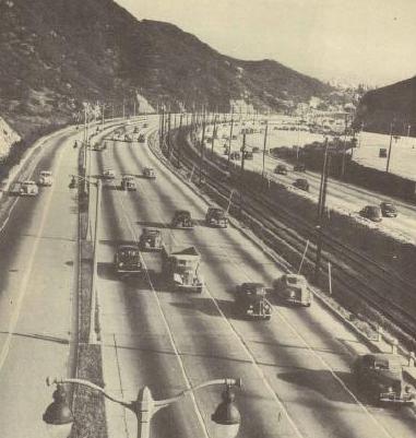
It’s a much different world now than in 1946 – clearly illustrated by this photo from the parkways report, captioned “Heavy Traffic Flowing Smoothly On Parkway”:
