![]() We recently discovered a fascinating 1922 PhD. dissertation from University of California, Berkeley that is a treasure-trove of various maps and charts. J.M. Terrass wrote his Study and Plan of Relief of the Street Traffic Congestion in the City of Los Angeles, Calif. to complete his doctoral degree in Civil Engineering.
We recently discovered a fascinating 1922 PhD. dissertation from University of California, Berkeley that is a treasure-trove of various maps and charts. J.M. Terrass wrote his Study and Plan of Relief of the Street Traffic Congestion in the City of Los Angeles, Calif. to complete his doctoral degree in Civil Engineering.
The dissertation (105p. PDF) is a snapshot of transit and transportation issues in Los Angeles during a period of unprecedented growth. But what made this particular period so critical in Los Angeles history vis-a-vis the need for relieving traffic congestion?
Consider the intense growth in vehicle registration in Los Angeles County in the preceding years:
According to the State Department of Motor Vehicles, Los Angeles County had 43,099 vehicles registered in 1914.
By 1922, that number had exploded to 172,313.
In just 8 years, the number of cars on the streets of Los Angeles had quadrupled.
The author also analyzes pedestrian traffic, regulation of traffic, the Los Angeles Railway and Pacific Electric Railway systems, and downtown parking.
He concludes that the downtown street area is insufficient for present traffic, street area is inefficiently used, outlets for traffic are insufficient, and that increasing efficiency is practically impossible due to the railway systems in operation at the time. He goes on to discuss the 2nd Street Tunnel project, the opening of 5th Street, the Pacific Electric tunnel, and plans for a Union Passenger Station.
The Union Station blueprints and plans are an interesting collection of various proposed terminals and locations, including this three-dimensional Grade Crossing Elimination And Union Depot Plan, as adopted by Southern Pacific Company, Los Angeles & Salt Lake Railroad and Pacific Electric Railway.

Mr. Terrass proposes several recommendations in his conclusion. These include rerouting nearly all Pacific Electric tracks and elevating them, a Spring Street subway, new tunnels, street widening, and amendment to the City Charter allowing private capital to be used in building subways or elevated railways on public property.
Among the many maps and charts in the document is the “Official Transportation and City Map of Los Angeles California and Suburbs.” The original is quite a large fold-out page, so the file size has been compressed in order to be rendered readable and presented here in two parts.
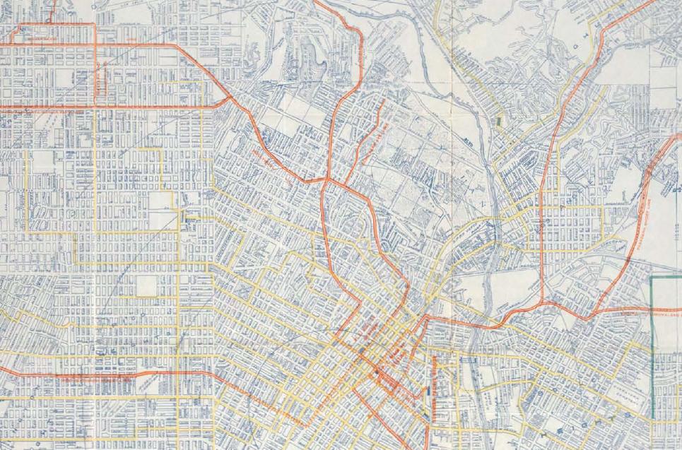
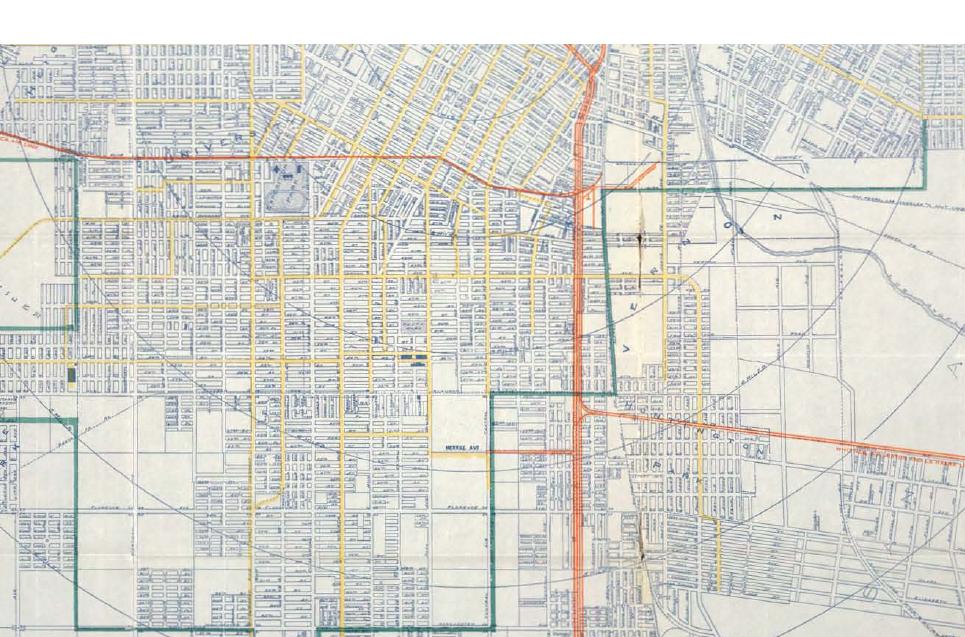
If you’ve ever visited the Metro Transportation Library on the 15th Floor of the Gateway Plaza Headquarters, you may have noticed a similar map mounted on the wall near the entrance. That map, circa 1928, also features the Pacific Electric Railway (Red Car) and Los Angeles Railway (Yellow Car) lines. as Olympic Boulevard had not yet been renamed (from Country Club Drive) and re-aligned through the Mid-City area in time for the 1932 Olympic Summer Games in Los Angeles.
A noticeable difference between the two maps is that the 1922 rendering shows large swaths of undeveloped property west of La Brea and Highland. By 1928, the area had been entirely developed – a testament to the explosive growth of Los Angeles in the 1920s, during which the city’s population more than doubled.![]()